Showing posts with label Wargaming. Show all posts

Friday, June 3, 2022

Lohwand: A Cosmology, based on the writings of Timeon of Ar


The Cosmology of Lohwand,
as proposed by Timeon of Ar

When Timeon of Ar first proposed his cosmology of Lohwand he was still only a low circle adept reading at Leomund College in the Unseen University of Ar. But such was the impact that he was permitted to submit it as his devotional labour for the year, gaining his tenth circle ranking as a result. Many felt he deserved better: some even dared to suggest immediate promotion to initiate, even though this would have meant skipping the intervening ten senior adept circles. Most scoffed at the idea, however, and the Archchancellor never considered this for a moment, even if he did concede privately "that dang kid might be onto something."

Here then is my simpleminded attempt to explain Timeon's proposal as I understand it:

First and foremost is the concept of "Reality", governed by the Law rune as scholars have argued for centuries. This rune serves to contain three overlapping planes of existence: the ethereal reaches of the Spirit Plane, the Plane of the Five Elemental Lords, and the mundane Physical Plane - that is to say, the world around us.

Where the Spirit and Elemental planes intersect lies the Dreamlands, an ever-changing realm which can be reached by mortals via the Astral Plane, which Timeon describes vaguely as the sinews that holds everything in place.

The Underworld lies at the intersection of the Spirit and Physical Planes, again reachable via heroic questing on the Astral Plane. This is more the domain of the Priests and I leave further explanation to them.

At the junction of the Physical and Elemental Planes are the infinity of the Multi-spheres, what Timeon claimed as infinite versions of the Our World - and an infinite host of others - reaching forwards and backwards for all Time. Yeah, I understand that as well as you! Again, he claimed that travel to and between the spheres was possible, presumably via the Astral Plane. Timeon himself mentions passing through shell of one sphere into another, but nowhere does he mention how he thinks this could be done.

At the central intersection of the planes, Timeon posited that Time rested, he writes about it as if it were an entity. He also - heretically, I might add - stated that this was where the Great Old Gods originated and might still lurk. The Archdeacon had to over-rule many calls for a heresy trial at that claim!

This Construct of Reality, as Timeon termed it, resides floating on the Seas of Illusion, which in turn are encapsulated by the never-ending Void. Timeon claimed that the Void was a vast expanse of Pure Nothingness across which no person nor even any thought might traverse. "The Kid's Cuckoo!" many responded to this outrageous claim. I make no judgement either way.

Perhaps most disturbing was Timeon's assertion that Chaos was seeping back into the World. He depicted it as a sphere of volatile Chaos essence that is moving into the planes of Reality. He speculated that the Seas of Illusion had gradually eroded cracks in the protective Law Rune allowing Chaos to infiltrate our existence again. He gave examples, but all are too sensational - and, if true, horrifying - for me to relate. The Archdeacon is said to have studied these latter assertions at length, retiring to his chambers and calling on many great minds for lengthy consultation and debate. What his final verdict was, I know not, but it seems likely to me that in the end these accusation were dismissed as wild imaginings. On the other hand, Timeon was granted his circle advance, so who can say?

Note: This is background for my justification of Magic in my Lohwand campaign. No doubt readers will recognize the many sources I am borrowing from as inspiration. Apologies. :-)


Friday, January 21, 2022

Isandlwana - Laundry Day Rules - 2nd Rinse


Some slight additions.

Added: close order and defenses to the melee and morale sections.

Unfortunately we decided that with omicron sweeping our communities that we could leave our refight of the battle until another day. It would have been nice to do it on the anniversary but not essential. Anyway, I'm not ready yet. I might have been but once that decision was made I slacked off somewhat so I am a bit behind schedule.

I have been tinkering with the rules, adding bonuses for close order and defending defenses. And also a Yes/No aspect to the Fate Table. 

Another thing I might add is an answer to where Durnford's ammunition supply ended up. Vause's troop escorted it to camp but thereafter it is not mentioned, and of course, Durnford and the men with him had no idea where it was, hence their ammunition supply problems. AFAIK no orders were issued to set up a camp from Durnford's column, though if there were then presumably it would have been on the South end beside 1/24th. As I see it, the wagons could have been left on the Western side of the Nek, or moved to where this new camp might be established, or perhaps moved up to the NNC camps. So when an NCO or Officer is sent to retrieve ammo he has a bit of a problem. From accounts of the battle the ammunition supply was not located, so I'm guessing it didn't have a big sign on it! I'm thinking a random draw of chits from a bag, with one draw per turn and only one chit being the correct location. If somebody thinks to ask Lt Vause then they get two chits.

Thursday, January 13, 2022

Isandlwana - Laundry Day "Bloody Spears!" edition (Now in Tabloid!)


Page 1


Page 2

This is the most recent version of my "Quick-and-Deadly" Zulu War rules: Laundry Day - "Bloody Spears" edition. Note that under these rules the players are intended to take the role of Imperial Officers, while the Zulus are controlled by the referee. That said, I intend to make the British players make all the Zulu die rolls themselves; I'll just move the bases and deploy the Induna as necessary.

Zulu movement is pretty much pre-programmed by the actual events of the battle and so there is little referee input required anyway, except for the question of when to employ the "Induna Inspiration" rules. Each wing of the Impi, and also each regiment, has 1 or more Induna, who function as "Fate Points" to try and inspire the pinned down regiments to action. The Induna is placed on the table the turn before it is used. The following turn during movement, and as a regiment is being activated, the roll is made on the Fate Table to determine how successful the Induna is at inspiring the unit.

Sunday, January 2, 2022

Isandlwana: umCijo Musters


umCijo

umCijo musters before the Great King, Cetshwayo, approximately 2500 warriors strong on 25 bases.

Thursday, December 30, 2021

Isandlwana - uVe Musters


uVe


Showing the lines of the component companies.

uVe regiment musters to receive its bases from the Great King, Cetshwayo, played in this instance by moi. Note the new, smaller bases (3" circular plastic labels purchased from Uline.) 

The regiment is approximately 2000 warriors strong on 20 bases. In comparison, each company of the 1/24th will have 16 figures plus a few separate NCOs and officers, and will occupy a frontage approximately 2/3rd that of uVe when in extended order (as they will be, per Lord Chelmsford's standing orders.)

Thursday, October 21, 2021

Isandlwana - Mod Podge Mountain


Isandlwana... a W.I.P.

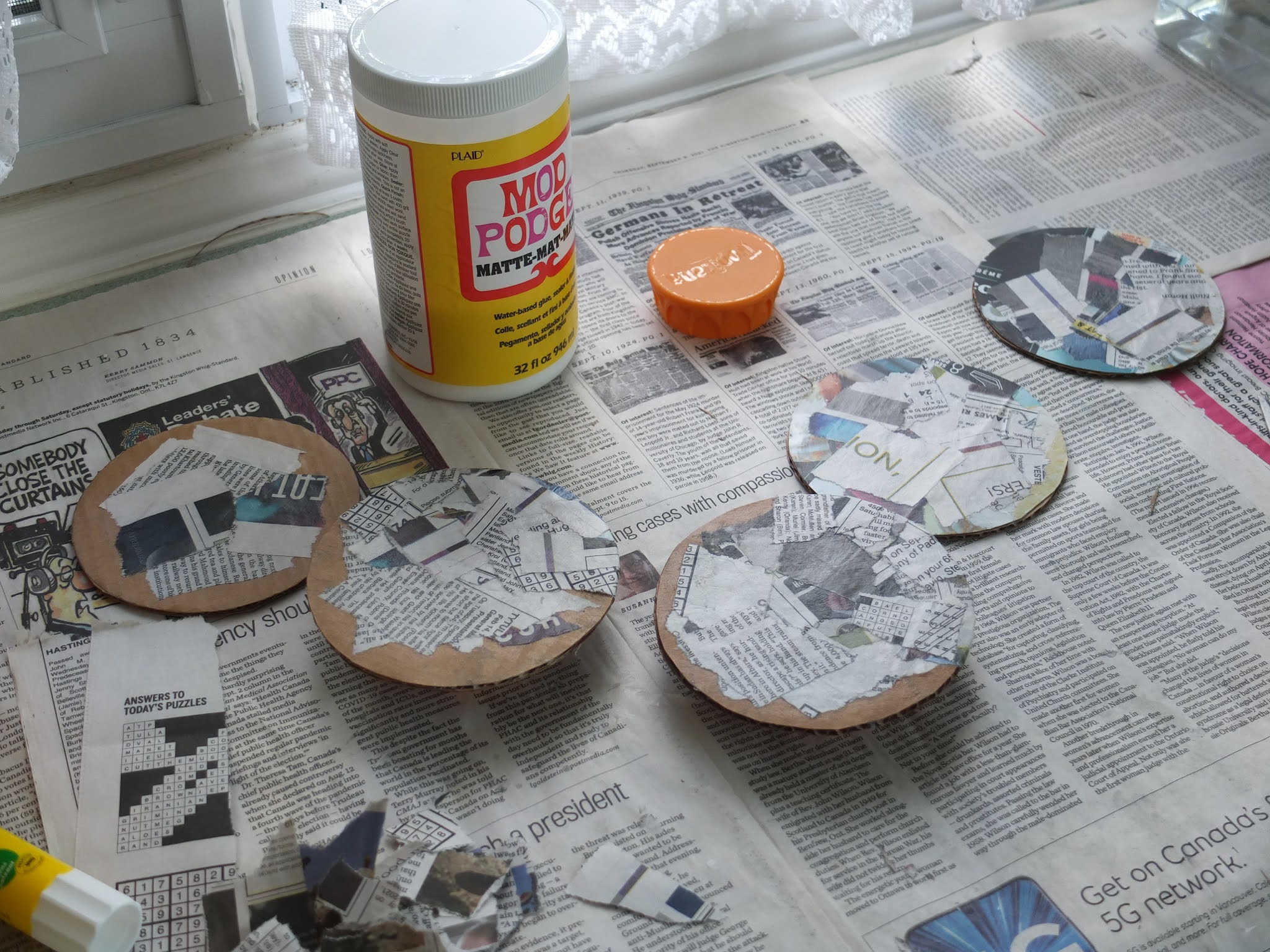
So, the Mod Podge Mache continues. I've got about three coats on I reckon, or close to it. I'm using Mod Podge - the "water-based glue, sealer and finish" by PLAID - instead of traditional paper mache. It seems to work fine, despite the "4 week cure time" mentioned on the tub. I just started my second 32 fl ox (946 ml) tub last night. So, between the amaTushane kopje, a few Zulu bases and this, that is how much paper mache I've done. The latest work has been to go around the edge and cover the base cardboard. I don't think I'm going to do underneath, though it might make it stronger if I did. (hmm...)

I've also been scrutinizing what photos I can find of Isandlwana before I tackle the upper bit; I didn't want to just go from a "mind's eye" impression. Unfortunately the period photos all seem to be from the same angle, or close to it. I'll just have to keep in mind that the more detailed modern photos reflect 140 years or so of wind and rain erosion. 

The plan is to cut the upper part down, both with vertical crevasses and possibly to shave a bit off the bulk. When I built it up I just sort of "winged it" and I might have over did it slightly. I'm away on the weekend so I'm not going to get back to it until late next week, but at least it'll be well dried by then.

Sunday, October 17, 2021

Isandlwana - the Impi Takes Shape


Zulu Movement Bases 
Still W.I.P.

Here are some "test bases" I did as a sort of "proof of concept". Each base is 100 scale meters across and represents 50-100 Zulu warriors. I was just trying to work out in my head if that density was reasonable...what's the formula again? I think that in close order, it is probably too low a ratio, but in open order - and I think the Zulus would be in a more open order - than I think perhaps it is not too unreasonable at the 1 base = 100 Zulus. What do you think?

That means 20 bases for a typical regiment. 

The bases start as the printed sheets, which I am printing on North American "Letter" sized paper (i.e. 8.5" x 11"). This because I am situated on the wrong side of the pond, and in Canada, while using the metric system we still use the same paper sizes as the USA. (Except, of course, for the work drawings I do which typically use ISO B1 sized paper (1000mm x 707mm). But that's Canada for you - a melting pot for everything, not just culture!

The process I've settled into is to print the sheets then mount them on a fine cardstock before cutting out the strips. I found that the paper I have isn't thick enough on its own. Maybe I am over compensating but it seems to work. The four paper layers and three layers of glue make for a pretty sturdy construct - provided I make sure I've got the glue properly distributed!


Sheets cut out and glued to fine cardstock.


One hour and ten minutes later... 
the strips ready for folding and gluing.

Then comes the cutting out!

Thursday, October 7, 2021

Isandlwana - Not Limited by the Counter Mix


Peter Dennis' Zulu War Paperboys


An Inventory...

Unlike many wargames, I am not "limited by the counter mix"! How can I when, if I need more, I can just print them? :-)

I decided to do an inventory.

Shown are approximately 1800 Zulus and an uncounted number of Imperial Forces. At 1:10 ratio that is more Zulus than I actually need as not all were engaged, and there won't be room for the entire right horn anyway. What is more important, however, is the proper proportion of shield colours. I'm still trying to sort that out. The colours are: Black, Black and White, White, Red, Red and White. Some regiments, like umCijo, need to be all black, but others can have a mix, or so I gather from my research. 

Regarding the British, my intent was to provide different bases for different formations and "States". So, extended order vs close order, etc. The "States" would be come into play when a section is broken up by contact with the Zulus, and are intended to show ever greater fragmentation and disorder. So, basically I need multiple bases for each company to show all of that. For the cavalry there are mounted and dismounted versions (including horse holders.)

Also, terrain building continues: amaTutshane.

Transformed from paper mache "hat", to "pudding" - as one friend dubbed it - to almost finished kopje.


"Hat"


"Pudding"
with Burnt Umber undercoat


Drybrushed with Raw Sienna


amaTutshane
Awaiting flocking...


Saturday, October 2, 2021

Isandlwana - a Small Update


Prone Zulus, taking cover from the British fire...


Casualty Markers


Zulu bases, in progress...


amaTutshane

A few things to report for this update. I've been snipping out figures for both the British and Zulus at a good rate, the casualties and prone figures shown being the easiest to do. The combatants are being worked on, but are not based yet.

The bases for the Zulus are going to be 120mm rounds which I have cut from corrugated cardboard. Being a bit paranoid about them warping I have been trying various things and recently realized that I needed to paper mache them to cover edges where the corrugated cardboard shows.

I've also been working on a couple of larger square or rectangular tents for the camp but not found a design I like yet.

I decided that my version of amaTutshane was too tall in relation to my version of Isandlwana itself so I have cut it down and trying to get the approximate shape right with paper mache. By my estimation it needs to be about 1/4 the height of Isandlwana

Tuesday, September 14, 2021

Isandlwana - The Camp Takes Shape


Left-to-Right: 1st/24th, Mtd & HQ, 2nd/24th, NNC, NNC,
wagon park on the nek.


Question: Where do the oxen and mules/horse go?

(They seem to get left off maps of the battlefield all the time!)

Sunday, September 12, 2021

Isandlwana - the Lower Storeys


The lower storeys take shape...


This is where the rock face ends...


 ...and the steep slopes begin.


The Eastern slopes, with that 
prominent knoll overlooking the nek.


The Western Slopes.

The next step: paper Mache!


The amaTutshane kopje, 
another prominent landmark on the battlefield.


Sunday, September 5, 2021

The Battle of Isandlwana: Some Battlefield Research


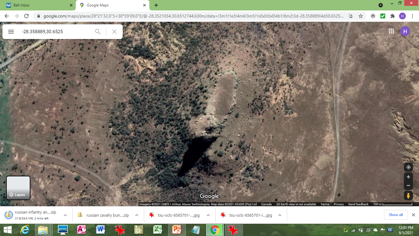
The Isandlwana Battlefield - via Google Maps

I am preparing to run a wargame version of Isandlwana later this month and have been doing some research to figure out how to set everything up. Luckily, a friend is allowing me to use his 6' x 15' table which, with the ground scale I've adopted works out at just about 4 kilometers. Google maps has a little measuring utility that allows me to measure and display that on the map, as shown above.


Isandlwana topo

Edit: ignore my tentative Chelmsford placement. 
I mistook the name of the hills. 
His force is down off the SE corner.

The University of Texas has a really good map library: 


This is The Perry-Castañeda Library (PCL) Map Collection. Apparently they have decided not to update it further and it was archived this year. Hopefully it will stick around as there are some really great maps there!

Anyway, I located a topographical map of South Africa and cobbled together the above image in PowerPoint. Comparing it to the Google satellite imagery one can see why it's reliability is only rated "fair"! Still it does give a rough idea where things were, and, more importantly for me, it gives me an estimate as to how high the ridgeline was. Going by the above map it is somewhere around 250 feet above the surrounding lowlands.

I'm still trying to work out how high the Isandlwana "mountain" is. It's not that large, actually. The footprint, I mean - see the image below. According to Google its only a couple of hundred meters long and less than 100 meters wide.


The above image shows a possible table layout. I realize now that my arrows for the Zulu Right Horn and Reserve are probably wrong. If the Right Horn was seen sweeping across Cavaye's front when his company was up on the ridge - and 600 yards to that front - then the sweep of the horn must have been much further westwards, leaving the map probably still on the ridge, then descending and doubling back. the end of their arrow would have been moving eastwards over the gap.

More to follow...

Sunday, August 22, 2021

Lohwand: The Tharkallan Legions Revisited


Detail of the 1st Cohort


Cohort Organization

After a year of focusing on 60mm figures, I have determined that the sort of battles I want to fight will require more units and larger numbers of figures. The 60mm figures are great and I still intend to use them for smaller battles, skirmishes and Gangs of Rome style games (I'm getting GoR bases printed in the correct size) however, I've decided to go down in scale for the large battles.

After a tentative stab at 25mm, which didn't work out to well (the figures received actually measuring 30-32mm!!!), I've settled on 15mm. The above EIR miniatures are from Museum Miniatures. I like the poses and I especially like that they have the same helmet crest as my 60mm plastics. 

Now that I've decided on a smaller scale figure I've been tinkering with organization and figure ratio. Another thing that has changed is that I know a little more about Roman legion organization than when I started the Lohwand Campaign. Following on Peter Connolly, I now know that the cohortes were organized in six centuries, each of eighty men, and that a common formation was three lines of two centuries each. Each century would be formed in ten files of eight ranks deep. So the whole cohort would be twenty men wide by twenty-four men deep. 

Quite a change from my original proposal which had a longer frontage rather than depth. Above you can see what I've more-or-less decided upon using a 1:40 figure ratio so each century is two figures strong. I found some nice bases - via the Big Red Bat (To The Strongest) - that are aligned the way I want them, short edge to the front.

I put the centurion in the front rank, and behind I've made a little command grouping of Optio, Signifer and Cornicen. I'll have to make sure the first cohort gets an Eagle! And for the overall legion I'll have to hunt down a Legate and an Imagifer.

The thing I'm wondering now is whether I should leave it as that, with the cohort the smallest element of maneuver, or should saw the bases so that I can array the centuries all in a single line? I'm thinking if I got a metal plate and then used the magnets with the holes already provided, that would hold the three-part cohort in place if I did cut it up, but still allow me to split the centuries up if required.

The pics below show the whole hypothetical legion arrayed in the triplex acies formation:


The triplex acies


The full legion of ten cohorts

Wednesday, August 11, 2021

Armatura X


Armatura X - Front


Armatura X - Back

The latest version as of Aug 11, 2021. The final version? Who can say?!

Note: I find that by opening each page "in it's own tab" (Right Click option) I can enlarge it to make it easily readable.

I have to start thinking about Battle Magic and about doing a functional "Cheat Sheet". My goal of getting a complete set of rules onto a single sheet of paper (back & front) is almost complete. Paper size: Tabloid (11" x 17") - which might be considered "cheating" b/c it is so large but I don't care. ;-)

Saturday, June 26, 2021

Lohwand: Mapping the Tharkallan Empire


The central Heartland Provinces:
Jharkor, Dharijor and Dharjiin,
Tharkallan Empire

It has been awhile since I last posted, but that does not mean that I have been entirely idle. I've been plugging away at a variety of things: my Armatura rules, background development and map-making. 

The above screencap shows some of the recent progress in three of the central "Heartland" Provinces of the Tharkallan Empire. Some may recognize Nemedia Province, to the east, with Belverus and Ilisi as its main cities. South of that is Voria Province, with Rinliddi as its capital, and also featuring Zoria, the "City of Free Love". As with so much of my inspiration, this comes from Glorantha, specifically the Life of Moonson series of supplements. I was so taken by the plot and by the characters that I have gone to great lengths to incorporate them. My hope is to build them into the running of Tharkalla - the development of my nobility, and Imperial bureaucracy, took a great leap forward when I decided to do this.

Southeast of Voria, down next to Vonlath, the province of Bisset is still largely unmapped. The only things I really know about it is 1) the capital is Yuthuppa and 2) that the province went into revolt as a result of the Comet passing during The Year of the Comet. 

Southwest of Voria is the Heartland Province of Jharkor, with the capital city of Thark (and the Imperial City-within-a-City of Glamour, and Vernkor, the associated port city.) 

I've added some geographic features not shown on my world maps. The Lake of Vermillion Mists is inspired by a blogger that I follow, and is lifted, not quite in its entirety from his blog: From the Sorcerer's Skull.

West of Jharkor is the Heartland Province of Dharjiin, with Jord, the Ebon City, as its capital. This is where I was tinkering today, adding the Shadow's Dance, the Shadow Vale and the Castle of Lead. All lifted from Glorantha and all Troll-related. Gloranthan Trolls remember - not the D&D variety!

North of Dharjiin is the Heartland Province of Dharijor, with Alkoth as its capital. Alkoth is the home, just as it is in Glorantha, to the bat-shit crazy, fanatical devotees of Shargash the Destroyer, God of War. What are they like? Hint: "Kill You" is the name of one of their auxiliary cohortes. Per Glorantha fluff, the Alkothi hate Darjiini! No "Happy Families" in the Heartlands! South of Alkoth is the Henjarl, a vast swath of reeds and marshes. Western Dharijor is the County of Spol, again inspired by Glorantha and specifically by the Life of Moonson Characters. Kitor is the capital of the County. To the west of that is Shadow's Dance, Troll country, nestled in the Rockwood Mountains. As one approaches the Shadow's Dance one notices the light gradually dims, even at high noon, until around Kitor and in the foothills there is perpetual dusk during the day. This is a magical effect and is attributed to the proximity to the Castle of Lead and the strong Troll presence in the region. For those that don't know, Gloranthan Trolls are Darkness creatures, originating in the Underworld. There are five Elements in Lohwand, just as there are in Glorantha: Fire, Air, Water, Earth, and Darkness. Darkness Elementals are called "Shades" and Shadow's Dance gets its name because it is said the shadows move there.

On the far side of the Rockwood mountains are the two Heartland Provinces of Kostaddi (in the North) and Karasal (with its capital at Torquas) in the South. I have only begun to think about developing these areas.

Also of interest on the map are some small diamond-shaped symbols. I am using this symbol to represent forts. In Dharjiin, Jharkor and Voria these are Amazon hillforts. 

These are once again inspired in part by Glorantha. In Lohwand Amazons are somewhat like Celts, warlike tribes with chariots and warbands of infantry and only a few cavalry. Though they resemble human females they are not, strictly speaking, human; or not entirely so, perhaps, is a better way of putting it. Possibly they are a branch of humanity. As in Glorantha they are strongly associated with Tolat, a God of War and Lust. Their entire biology relates to the God, and so it may be they are Children of the God, rather than actual humans. "God-Born", is that a good term to use?

(To further complicate matters Shargash and Tolat are often equated with each other.)

Tolati Amazons do not mate with human males. Instead their birth cycle is tied to the meteor showers, i.e. manifestations of the God, that occur twice a year. A certain number of Tolati will become pregnant during these events and will give birth a season later, with the young growing to maturity after another season. 

Like I said, they are not human, strictly speaking. Whether they were in the past is another question. Of course, the Comet is an extreme event, being strongly associated with Tolat and resulting in a rapid [unlooked for and unwanted] population increase.

Most of the Tolati Amazons are in the Atlan Confederacy, to the east, off the map: Ologog, Oronin and Oraya are their Queendoms. But, as you can see, there are Tolati within the Empire as well. This roughly parallels the Gauls in Northern Italy during Roman times.

For figures I am using the Artizan Guild 3d printed Amazons, which I am up-scaling 185% to match my Expeditionary Force 60mm Romans. Note that LOD also make Amazons, but a number of things put me off. Firstly, when I attempted to order a bunch the online store claimed they could not ship to Canada (!) - this even though I had ordered online once before - and second, the poses are all based very closely on the art of various Ancient Greek vases. I said "very closely" and I mean it - I personally do not find many of the poses to be that useful. I am still going to get some: there is an Amazon Greek faction on Lohwand, and I want to mix the horse archers in with my Scythians.

Another mapping development is the mountainous barbarian land of Dunland. Inspired by? You guessed it: Tolkien's Dunlendings. Dunland is located on a plateau and consists of several tribes with a High King. The eastern tribal stronghold of Wintertop was stolen and taken over by The Exiles, the former nobility of Nemedia who fled there when their kingdom was conquered and incorporated into the Tharkallan Empire as Nemedia Province. This is once again inspired by Glorantha. :-)


Dunland


Dorastor and the Bossonian Marches

Lastly, here is the map of Dorastor. Gloranthaphiles will recognise the name as well. In Glorantha, Dorastor is a region steeped in Chaos, and most of the inhabitants are tainted by Chaos in some way, and so it is in Lohwand. 

The Tharkallan Empire takes much the same view of Chaos as the Lunar Empire does on Glorantha, though I want to stress that the two are not equivalents. I want the Tharkallan Empire to also have a bit of Granbreton from Michael Moorcock's Hawkmoon series, and also Melnibone from his Elric books. But right now, this is a bit of its Gloranthan inspiration. 

Dorastor is almost an unofficial province of the Empire. But the Bossonian Marches still exist to guard against the Chaos threat from Dorastor and also the Wenelian Forest Tribes that dwell in the Great Forest of Rist, off-map to the north. 

This is a work-in-process map. Shown are the forts garrisoned by auxiliaries like the Bossonian Longbowmen, and others. The southern river is the Oslir River, while the Black Eel River is the northern-most one. Beyond the Black Eel River is the Bush Range - another idea borrowed from Glorantha.

Here are the regions:

The Bossonian Marches
B1.1 to B1.6 East March
B2.1 to B2.x  River March (not shown yet)
B3.1 to B3.x  West March (not shown yet)
B4.1 to B4.x  The Bush Range (not shown yet)

Dorastor
D1.1 to D1.8 Hellwood
D2.1 to D2.6 Riskland
D3.1 to D3.3 Bonewood
D4.1 to D4.3 Ash Wastes
D5.1 to D5.5 West Poisonthorn
D6.1 to D6.5 East Poisonthorn

Orthanc

The Dorastor regions are much like their Gloranthan counterparts. Hellwood and Poisonthorn Forest are both inhabited by Elves, those in Hellwood bearing a chaos taint. Riskland is a region with a few hardy, and brave, Steaders.  Bonewood is a forest of petrified trees, while the Ash Wastes is as the name implies. 

Orthanc represents the only built-up area in the region, other than the Marcher Forts. Also called "The White Tower", it is a remnant of the Keoish Kingdom at a time when Chaos was thought vanquished from the area, but to guard against its return. It is still a place of powerful magic and so the chaos taint is almost nonexistent within its walls. 

The Lord of Orthanc is called Ralzakark - immediately recognizable to Gloranthaphiles! He takes the form of a Unicorn-headed Broo, typically clad in long white robes, and is as soft-spoken, and seemingly mild-mannered as any pampered, city-born aristocrat. He has a treaty with the Tharkallan Empire:
  • Under that treaty he ensures that the Riskland homesteaders are not molested - at least not on a regular basis, nor by any of his own forces. 
  • He also keeps open the old Keoish trade route north through the Great Forest of Rist, at least as far as the Last Fort, where some limited trade is conducted with Wenelian, and other forest tribes, such as the Tusk Riders. 
  • He guarantees that Orthanc remains disease free. 
  • Lastly - and this is not commonly known - he supplies legions of Sword Broo to serve in the Tharkallan armies in Granbreton. These are also guaranteed disease-free.
This is why I referred to Dorastor as an unofficial province of the Empire. This is all pretty much as in Glorantha, I think, with some tweaks here and there.